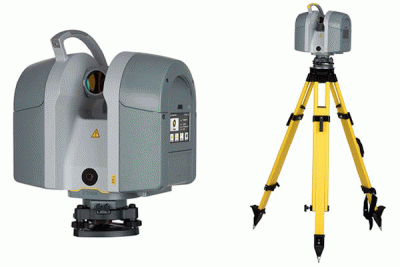
top of page

PROJECTS

TOPOGRAFI
 

Topographic surveys are surveys aimed at finding ground level information. Such information may be of a low height to the physical state and position of an object, whether natural or man-made, on the surface of the land to be mapped.

UAV DRONE
 

Unmanned Aerial Vehicle (UAV) is one type of unmanned air cruiser robot. Unmanned Aerial Vehicle (UAV) is also commonly referred to as the "Pesawat Udara Nir Awak (PUNA).

LASER SCANNER


As the name implies, this tool serves to scan a 3-dimensional object (remotely of course, without having to touch the object), convert it into CAD drawing, to then further processed using software specially made by the manufacturer of the Laser Scanner tool.

BATHYMETRY


Bathymetry is a mapping of contours in the ocean In the seafloor mapping or Bathymetry instruments we commonly use include echosounder or fishfinder. Both instruments are working principles using underwater acoustics.

Professional Survey & Mapping Services

bottom of page