top of page


Equipment Rental
PT. Duta Basis Dataprima have enough equipments, so our equipment scan be rented to other companies in need. Our equipment list are:
-
Total Station (Nikon and Sokkia)
-
Automatic Level (Nikon and Sokkia)
-
GPS Geodetic (Trimble and Spectra Precision)
-
GPS Mapping (Trimble GeoExplorer 2008 Series and Juno Series )
-
GPS Navigation (Garmin GPSMap 76CSx and Garmin GPSMap 60CSx)
-
3D Laser Scanner Trimble TX8 Pro
-
Gyro Compass
-
Echosounder


Total Station Nikon and Sokia
Total station is an optical / electronic instrument used in building mapping and construction. The total station is an integrated theodolite with an electronic distance meter (EDM) to read the distance and slope of the instrument to a certain point.


Automatic Level Nikon anda Sokia
A waterpass is a ground measuring device used to measure the height difference between adjacent points. The height difference is determined by horizontal horizontal visir lines (horizontal axis) indicated to vertical measuring rods.


GPS Navigation
Global Positioning System or GPS, serves to help the bikers when traveling long distances or traveling at close range. On this GPS can display maps and directions, so when we get lost this GPS role play. But its function is not only that, read more to find out more about the GPS function for this bikers.


GPS Mapping
GPS Mapping is a GPS tool used for mapping and knowing an unexplored / remote area. GPS Mapping or also called GPS Mapping is used for map creation, GPS mapping accuracy can reach 30cm. Various products in Indonesia are Trimble, Magellan, Topcon, and others.


GPS Geodetic
GPS Geodetic is a GPS that has the ability to capture signal L1, L2, or GNSS. GPS Geodetic has the ability to record Raw data, which in general has the RINEX Format. This GPS has a higher accuracy than GPS Navigation. Its accuracy is even up to millimeters.

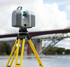
Trimble Laser Scanner
The Trimble® TX8 laser scanner sets new standards for
performance and ease of use in high-speed collection of 3D
scan data. Delivering state-of-the-art speed, and high precision,
the Trimble TX8 delivers the high quality results needed
for comprehensive worksite data collection.


Echosounder
Echosounder Is: An electronic navigation device using an echo system mounted on the bottom of a ship that serves to measure the depth of the waters, know the basic shape of a waters and to detect fish hordes at the bottom of the ship vertically.


Gyro Compas
Girokompas is a kind of non-magnetic compass based on fast rotating disk and the earth rotation (or other planetary body if used elsewhere in the universe) automatically finds geographic direction.
Booking
bottom of page